Pattern recognition algorithms allows the automatic recognition of different features and increasingly use ML and AI to train selected features. While classification of multi-band satellite imagery data follows a predefined workflow, classification based on pattern recognition algorithms has been greatly enhanced mainly because of increasing spatial resolution. The need for automation in extracting relevant information from multiband imagery is growing considerably especially with the Global Commercial Satellite Imaging market expected to reach $8,585.56 million by 2026 growing at a CAGR of 12.6%. (Stratistics, 2018). This white paper first evaluates the present and advanced techniques used in image pattern recognition and how deep learning, AI and machine learning could be used to automate the pattern recognition process.

Before we delve into the intricacies that define the various factors that influence pattern recognition, it is important to understand what actually entails pattern recognition. Simply put, pattern recognition is a classification technique that uses object-based sample training datasets to classify multi-band imagery. It tries to segregate the pixels based on sample training datasets, clusters them together and assigns them a cluster category. For example, object-based sample training datasets are similar to LULC objects like water bodies, road pattern, river, agricultural fields, urban areas, forest areas, etc.
Traditionally, most satellite imagery goes through a predefined process that typically involve pre-processing of raw imagery followed by classification using sample trained datasets and feature extraction. Based on pattern recognition techniques, multiband imagery uses algorithms that essentially analyses object’s pixel information, groups these pixels into clusters and classifies these clusters into features. Object based classification is more popular because of its higher accuracy as compared to pixel-based classification. (Weih & Riggan). A sample example is given in the image below that clearly show the differences in classification of various features like the river, road, trees, crop, building, grass using either of the techniques.

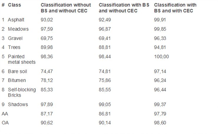
Furthermore, while pattern recognition algorithms have been applied to identify familiar patterns quickly and accurately, different types of classification algorithms like Minimum Distance from Mean (MDM), Parallel-piped, Maximum Likelihood (ML), Support Vector Machines (SVM), Artificial Neural Networks (ANN) have been used to accurately identify different features. The accuracy of multi-band imagery has also improved with the integration of spectral information with training classes. For example, the accuracy achieved for a multi-band hyperspectral imagery was tested using three evaluation techniques:
- Classification without Band Selection (BS) and without Classification Errors Correction (CEC)
- Classification with BS and without CEC
- Classification with BS and with CEC
The classification accuracy achieved is given in the table below. The fourth column (classification with BS and CEC) show higher accuracies as compared to the other two. (Medjahed, et al, 2016)
With advancement in computer processing power, improvements in new technologies, and the inherent possibility of automation of processes, pattern recognition is set to become much more intuitive than its present form. Technologies such as the new artificial computational intelligence model called Concurrent Self-Organizing Maps (CSOM), advanced object-based classification and segmentation of features, Statistical, Syntactical, Template Matching (ISTM Model) and Artificial Neural Network (ANN) model are some of the techniques that are being proposed and tested. The test results are encouraging where Hybrid ISTM model for satellite imagery-based pattern recognition gives more efficient and better results (IJTRS, 2017) as compared to ISTM Model and ANN Models. What is more encouraging is the trend to use automation tools that not only use a sequential workflow to process panchromatic or multi-sensor imagery, many open source tools are being developed and deployed for pattern recognition.
The success of ML, AI and Deep Learning techniques for pattern recognition and image is mixed. It has been established through multiple researches that convolutional neural networks (CNNs) – a type of deep neural networks – produce fairly accurate results when used for image classification. Using CNNs, it was possible to automate the classification of almost 100 classes with 600 training images and get 90% image classification accuracy. (Upendra Rajan, 2018). Google has also developed a machine learning algorithm that can classify large number of images using colour histograms, textures, and shapes. It uses CNN algorithm that progressively extract higher – and higher-level representations of the image content. (Google Course Work). Sadly, research in using multi-spectral imagery is under construction with few research attempts.
One of the most encouraging image classification automation of multi-spectral imagery using pattern recognition and machine learning has been demonstrated by the STARS Project team – a consortium of experts from the various Universities and Organisations in Netherlands, Australia, Uganda, Tanzania, Mali, Bangladesh and Mexico (STARS Project Team). The team gathered a vast array of sensor data from satellite, aerial platforms, like aircrafts and UAVs, and terrestrial sensors and developed an automated image processing workflow focused cropland mapping and deriving image products that were useful for further research. Using open source software tools like R and Python scripts, the automated classification workflow developed proved fruitful and effective.
Marc Wieland & Massimiliano Pittore, 2014 used ML algorithm to extract urban features using pattern recognition techniques on multi-resolution (MR) and very high-resolution (VHR) satellite images. Using four classification algorithms Normal Bayes (NB), K Nearest Neighbours (KNN), Random Trees (RT) and Support Vector Machines (SVM) (or probabilistic, nearest neighbour, tree-based, function-based), they used object-based image analysis. It was found that SVM and RT appeared to be the best performing classifiers on all image types while KNN and NB showed good performance in some configurations, but mainly lacked the ability to generalize and showed unstable behaviour under varying training-testing scenarios.
While the instances for using ML and AI for multi-resolution satellite imagery is still in its infancy, it is clearly a research area that needs further explorations. VHR imagery provides encouraging results to delineate urban features like rooftops, building footprints and road networks. Automation of the classification process will not only speed up the extraction of urban features speedily and accurately, it will help demonstrate the ML and AI as the next frontier in image classification.